

Update(9:05ET): Tropical Storm Hanna was upgraded to a hurricane on Saturday morning, making it the first hurricane of the 2020 Atlantic hurricane season.
Hurricane #Hanna Advisory 10A: Noaa Hurricane Hunters and Doppler Weather Radars Find Hanna Has Become the First Hurricane of the 2020 Atlantic Hurricane Season. https://t.co/VqHn0u1vgc
— National Hurricane Center (@NHC_Atlantic) July 25, 2020
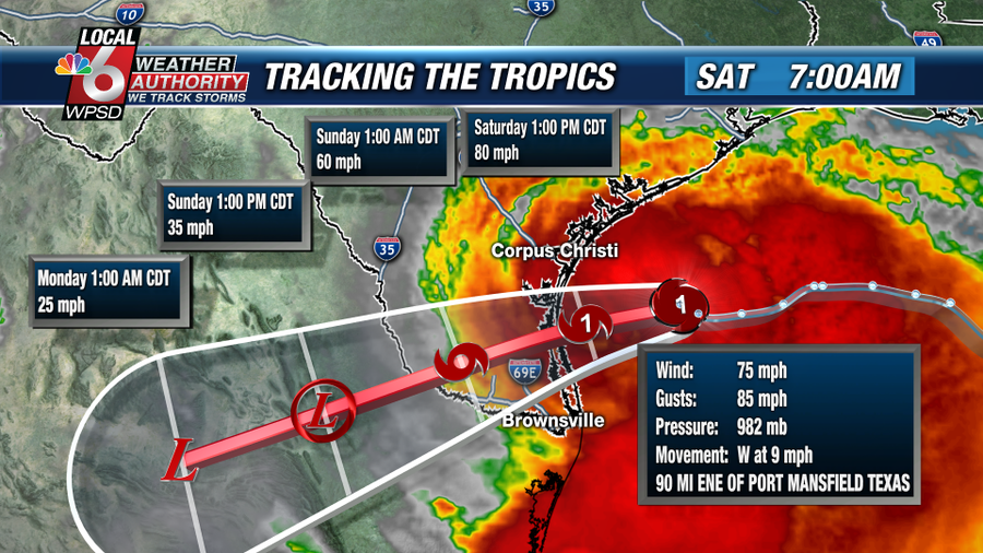
The National Weather Service (NWS) said NOAA hurricane hunters and Doppler weather radars show the system has maximum sustained winds of 75mph, meeting the 74mph threshold of Category 1 hurricane status. The system is moving west at 9 mph, located about 100 miles east-southeast of Corpus Christi, Texas.

AP News notes Hanna could produce life-threatening conditions for south Texas.
A storm surge warning in effect from Baffin Bay to Sargent was extended south of the bay to Port Mansfield, Texas. Storm surge up to 5 feet (1.5 meters) was forecast for that area. People were advised to protect life and property from high water.
Tornadoes were also possible Saturday for parts of the lower to middle Texas coastal plain, forecasters said. A hurricane warning remained in effect for Port Mansfield to Mesquite Bay, and a tropical storm warning was still in effect from Barra el Mezquital, Mexico, to Port Mansfield, Texas, and from Mesquite Bay to High Island, Texas.
Forecasters said Hanna could bring 6 to 12 inches (15 to 30 centimeters) of rain through Sunday night — with isolated totals of 18 inches (46 centimeters) — in addition to coastal swells that could cause life-threatening surf and rip current conditions. – AP News

Hurricane Hanna’s Landfall Forecast

Several spaghetti models show Hurricane Hanna’s potential path after landfall.

The tropics are very active.

Meteorologist Ryan Maue tweeted Thursday there are even more disturbances that need to “be watched closely into next week.”
A tropical wave is emerging off the coast of Senegal into the Atlantic. Two more are spaced out 4-5 days apart over the continent.
This disturbance will be watched closely into next week as it has potential to become a powerful storm.
Meteosat (00z July 24) #TropicalUpdate pic.twitter.com/jLLsw68MBG
— Ryan Maue (@RyanMaue) July 24, 2020
* * *
Tropical Storm Hanna was located by satellite and weather radars to be about 230 miles east of Port Mansfield, Texas, with winds about 50 mph. The storm continues to intensify in the Gulf of Mexico as it churns west-northwest at nine mph.

Hanna is expected to make landfall along the Texas coast Saturday afternoon. Winds could increase above 50 mph with higher gusts in the overnight hours. Tropical storm warnings have been posted for Galveston Bay, including the cities of Corpus Christi, Rockport, and Victoria. As the storm makes landfall, it could bring torrential rains, which may cause flash flooding across southern Texas.
KBTX meteorologist Max Crawford provides an update on Hanna.
#Hanna continues to strengthen as it moves west toward Texas.
Scattered to widespread rain is likely as early as this afternoon, but especially Saturday. Latest PinPoint forecast: pic.twitter.com/pMWkbyHN89
— Max Crawford (@KBTXMax) July 24, 2020
NHC’s latest update on the storm.

Tropical Storm Gonzalo is another system heading to the Caribbean waters this weekend. Barbados and the Windward Islands are expected to see tropical storm winds and heavy rains.

And if that isn’t enough, Hurricane Douglas is approaching Hawaii, which is currently the strongest storm on the planet, packing winds up to 120 mph. There’s also a tropical wave emerging off the west coast of Africa that could strengthen into a hurricane next week.

The 2020 hurricane season is certainly off to a busy start.
Harrison reacts to the many ways that Black Lives Matter supporters have shown unimaginable cruelty.
The Emergency Election Sale is now live! Get 30% to 60% off our most popular products today!